
There must be head scratching and debate when it comes to naming new roads and streets, but we will look at streets that were named a long time ago.
Many of these almost named themselves, Market Place, Station Road and Church Street are examples. East Street and West Street, although very obvious, are modified versions of older names.
East Street was East End, but it was the same street as the one we know today. West Street was West End, but it ran from the Obelisk to a point in Victoria Road, just beyond the Co-op stores. At this point, the road enters Bugley. It may not have had a name in Bugley, but sometimes it was known as the Frome Road and sometimes merely as the Turnpike.
There are other roads which had obvious names – that is, they were obvious when they first had names, but the obvious feature no longer exists. Chapel Street in the common had a Methodist chapel. The chapel closed, but the building was taken over by the Salvation Army. Many people will remember the Army, but now, even the building has disappeared.
Brook Street in the common ran alongside a brook, but even that is difficult to sort out now. What about Bread Street, also in the common? It is a long time since a baker in that street baked your home prepared loaf in his ovens. But South Street in the common does head south.
We can leave the common via Pound Street. Pound Street links Brook Street with Vicarage Street.
Before the open common lands were enclosed, stray animals were a problem. There was little to prevent an adventurous cow finding its way into the streets of the common, and then on into Warminster.
These animals had to be rounded up and put into a pound. They were held there until their owner could be found and the owner had to pay to have his animal released. There was a pound in Pound Street. It was on the north corner of the Pound Street/Pound Row junction. Pound Street then goes on to join Vicarage Street, a street without a Vicarage, although the old Vicarage building is still there.
There was also another pound not far away, in Bugley, close to Bugley Barton Farm. (Now, if we are being pedantic, we should point out that barton is an old word for farmyard, so we have Bugley Farmyard Farm).
We will leave the West End and move to East Street, where it meets Boreham Road. There was toll house here (later moved), with gates baring entry into East Street and Imber Road.
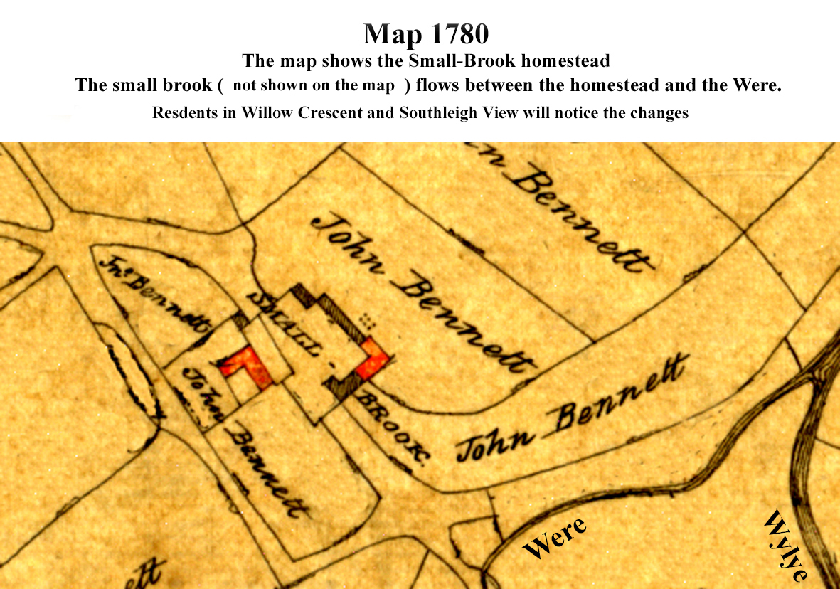
Just outside the gated area, Smallbrook Road meets Boreham Road. Smallbrook, at that time, was a small area very close to the place where the River Were joins the Wylye and close by, there was the small brook which found its own way to the Wylye. In 1780, the area labelled Smallbrook was the property of John Bennett.
Going back to the junction of Smallbrook Road with Boreham Road and travelling a short distance along Boreham Road, Chain Lane goes to our right. It links Boreham Road with Smallbrook Road. Chain Lane would be a very useful link between the two roads, but the old maps show that there was a chain across Chain Lane. It is likely that it was considered that this lane could not handle traffic, but that it was not worth the costs of improving it.
In jumping from West End to Boreham Road, we missed Furlong. I have never measured how long Furlong actually is, but 220 yards seems about right.
There is a much more recent interesting name. A new road linking Station Road and Imber Road was named Fairfield Road because the fairground was on the area now occupied by Argos, McDonald’s, B&M and Snap Fitness.


, which identified a number of locations as suitable for reduced speeds after assessment work and traffic monitoring.
The Wiltshire Council consultation is now open to residents and businesses, and runs until 13th July.
Read more on our website, the link is in our bio.")


 has raised £11,000 for the school in less than two years through a wide range of community events, including school fetes, colourful rainbow runs, discos and quizzes.
The funding has enabled the school to invest in a full class set of Galaxy tablets and has also been used to increase the number of iPads available to pupils.
Read more on our website, the link is in our bio.")
